Aerial LiDAR

AERIAL DATA TO MAKE BETTER DECISIONS

Aerial LiDAR

AirBorn Insight combines technical expertise with high-performance systems to deliver first-class aerial LiDAR services. Our engineers provide comprehensive project management to deliver results faster, empowering our clients to make critical decisions sooner. LiDAR technology plays a significant role in our aerial survey and mapping services. For cost-effective mapping of very large areas, we also utilise manned aircraft.

Aerial LiDAR

WHAT IS LiDAR?

ADVANCED LASER MAPPING

LiDAR (light detection and ranging) refers to a technology for aerial survey and mapping where a laser emits pulses towards the ground, precisely measures the time taken for the pulses to return and calculates distances. These data points create a 3D point cloud representing terrain and objects.

Although existing for decades, aerial LiDAR technology has only recently become compact enough to be carried by powerful drones. The benefit of LiDAR is its ability to map the ground in areas where there is dense vegetation. This makes it a particularly powerful tool for environmental mapping, monitoring and analysis. Many other industries also benefit from this technology.

Liidar

Aerial LiDAR

BENEFITS OF OUR AERIAL LIDAR SERVICES
Aerial LiDAR
Mapping Vegetated Land

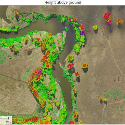
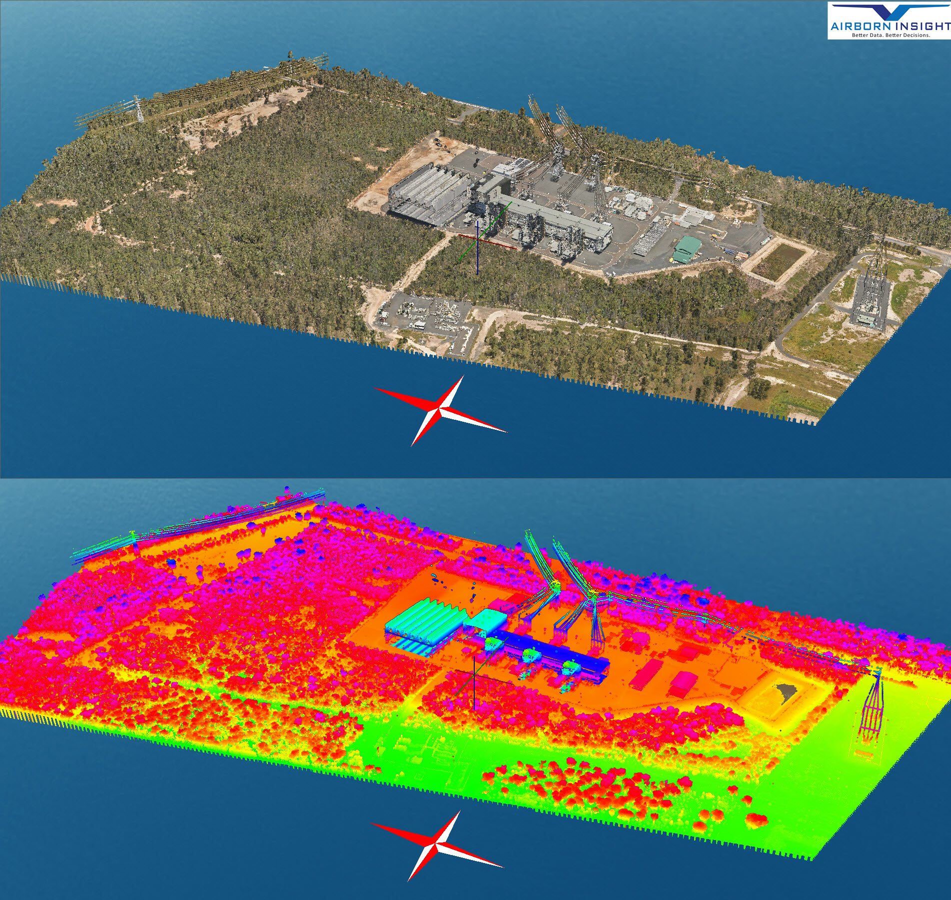
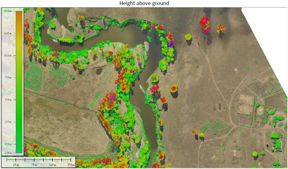
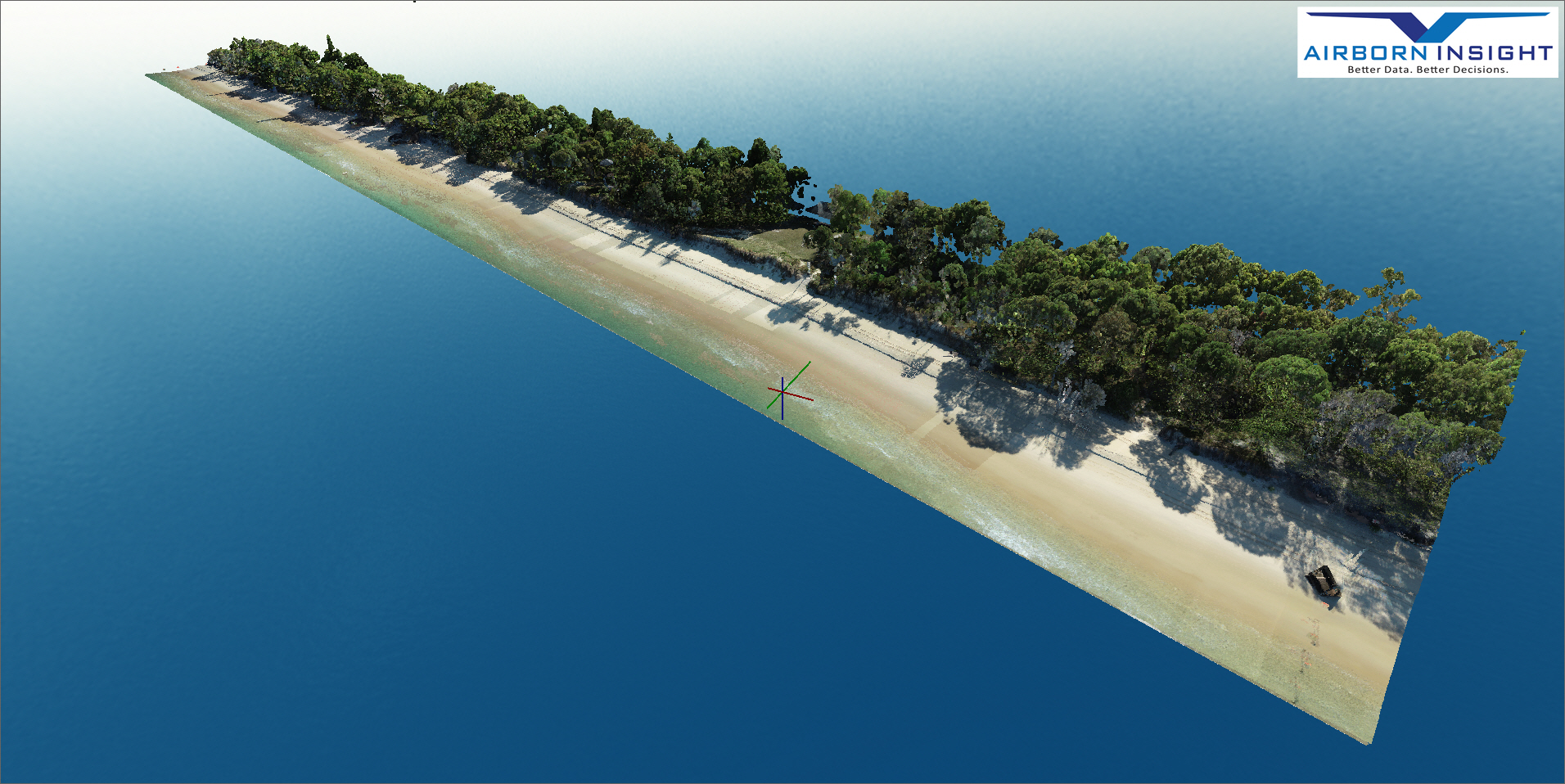
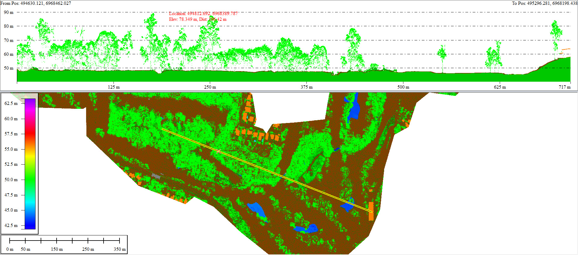
Aerial LiDAR can map the ground beneath dense vegetation, making it an effective tool for environmental assessments, agriculture, and ecosystem analysis.

Aerial LiDAR
Detailed Terrain Mapping

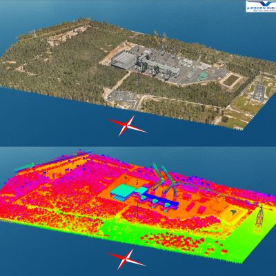
With hundreds of data points per square meter, drone LiDAR can capture intricate details of terrain, including elevation changes, vegetation structures, and ground morphology, which is crucial for land management and environmental monitoring.

Aerial LiDAR
Accuracy in Complex Terrain

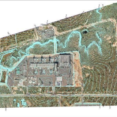
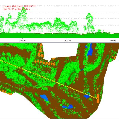
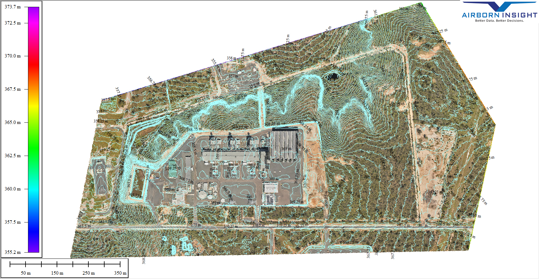
Aerial LiDAR is highly effective in capturing accurate elevation data in rugged and complex terrains.

Aerial LiDAR
Consistency in Data Quality

Our LiDAR quality remains consistent across different lighting and weather conditions, ensuring reliable results.

Aerial LiDAR
Long-Term Monitoring and Trend Analysis

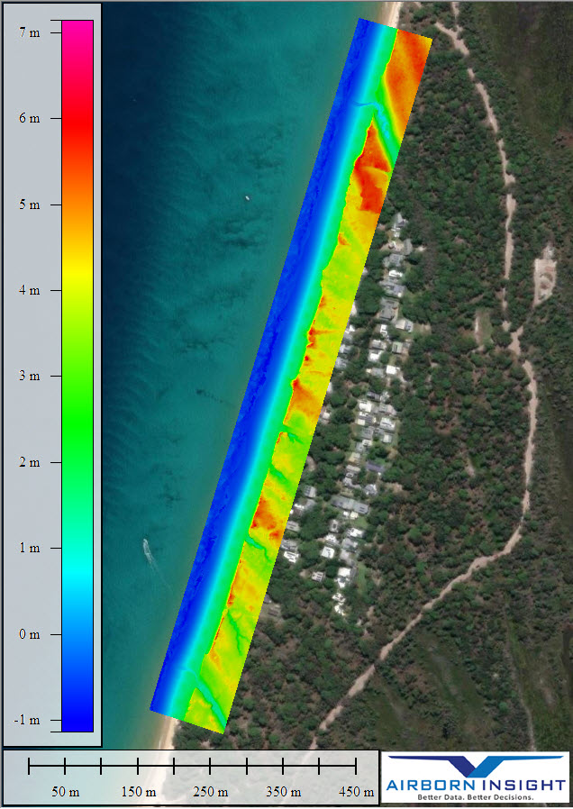
Our repeat LiDAR surveys allow for the detection of changes and patterns in environmental parameters, aiding in understanding and managing environmental issues.

Aerial LiDAR
Compliance & Reporting Benefits

We streamline compliance reporting with accurate, repeatable, and highly visual data. This improves transparency and simplifies regulatory reporting obligations.


AirBorn Insight bring professionalism, cutting edge technology and extensive experience. They capture the data we need and help analyse our complex natural environment so we can make better business decisions.

Mark Ward, Principal Restoration Innovation, Healthy Land & Water

AirBorn Insight are our go-to provider for aerial survey and imagery. They fully understand our needs and are excellent at what they do. I am always impressed with the quality and accuracy of their work, especially for repeat survey. I frequently recommend AirBorn Insight to my clients and stakeholders.

Dr Micheal Cheetham, Principal Scientist Water Technology


AirBorn Insight are a trusted collaborator of Bligh Tanner for survey and data collection on unique and often remote projects. We appreciate their professionalism and active involvement in projects to ensure that the data capture is reliable and will best achieve the project objectives

Riley Dejong, Civil and Water Engineer Bligh Tanner

Aerial LiDAR

WHY USE AIRBORN INSIGHT FOR AERIAL LiDAR?

AirBorn Insight seamlessly merges technical proficiency with cutting-edge systems to provide top-tier aerial LiDAR services. Our team of engineers excels in holistic project management, accelerating project outcomes and enabling our clients to make pivotal decisions expeditiously. LiDAR technology holds a pivotal position in our aerial survey and mapping services. To efficiently map expansive regions, we also harness manned aircraft, ensuring cost-effective solutions.

Reputation and References

We have a strong reputation in the industry, supported by positive client testimonials and references. Our reliability, quality of service, and track record for aerial LiDAR mapping have earned us the trust and recommendation of our clients.

Aerial LiDAR
Aerial LiDAR

Comprehensive Project Management

We provide all the essential elements for successful LiDAR services – professional consultation, precise surveys, in-house data processing, and proficient reporting and drafting services.

Professional Staff

Our professional engineers and licensed surveyors ensure precise data collection and accurate analysis for informed decision-making.

Aerial LiDAR
Aerial LiDAR

Reporting, Drafting and Visualization

We make it easy to interpret results. Our easily understandable formats facilitate the implementation of appropriate actions based on clear findings.

Efficient and Reliable Services

We can achieve the right outcome, first time, under a proven safety management system. We offer immediate deployment while taking care of costly equipment and the complexities of aerial LiDAR operations – training, maintenance, aviation safety management, documentation, and liability.

Aerial LiDAR
Aerial LiDAR

Advanced Technology

We utilize cutting-edge systems equipped with high-quality LiDAR sensors, cameras, and data collection instruments. Our advanced technology enhances data accuracy and enables us to capture detailed mapping data for comprehensive analysis.

Data Analysis Capabilities

Our in-house data analysis capabilities, including advanced software tools and techniques, allow us to process and interpret data effectively. We provide valuable insights for informed management decisions and actionable recommendations.

Aerial LiDAR
Aerial LiDAR

Customization and Flexibility

We are technically proficient at providing flexible solutions. Our engineers can adapt drone flights, LiDAR sensor configurations, and data analysis approaches to ensure the unique needs of your project are met.

Project Gallery

Aerial LiDAR

Aerial LiDAR FAQ

Measurements can achieve centimeter-level elevation accuracy, depending on the equipment, techniques, and ground control points (GCPs) utilized. It is more accurate than photogrammetry in certain scenarios, particularly where there is vegetation.

The turnaround time can vary depending on the scope of the project and data processing requirements. It can range from a few days to a couple of weeks.

Classified 3D point clouds, Digital Elevation Models (DEM), Digital Terrain Models (DTM), Digital Surface Models (DSM), Object height-above-ground calculations. Typical formats include LAS, LAZ, XYZ, ASCII grid, DWG, DXF, SHP, GeoTIF, ECW.  

Forestry, mining, agriculture, construction, environmental monitoring, archaeology, infrastructure inspection, and disaster response utilize aerial LiDAR for data collection and analysis.

Yes, drone LiDAR can work in challenging environments like dense vegetation, rugged terrains, and low-light conditions, providing accurate data that other methods might struggle to obtain.

Drone LiDAR can be limited by factors like cost, payload capacity of the drone, and the need for skilled operators. It might also struggle with extremely reflective surfaces or harsh weather conditions.

Yes, drone LiDAR technology is adaptable and can be used for projects of various scales, from small surveys to medium-scale mapping and monitoring tasks.

GPS (GNSS) provides accurate positioning data, while an IMU (inertial measurement unit) determines the drone’s orientation in space. Together, they enable precise georeferencing of LiDAR data.