Environmental Engineering

ENGINEERED LANDSCAPES FOR IMPROVED RESILIENCE

Environmental Engineering

We specialise in the design and oversight of gully and instream engineered solutions for environmental stabilisation/rehabilitation programs, reducing sediment and nutrient export in rural and urban settings.  Our advanced airborne technologies capture vital data to inform project design and to share valuable insights with clients.

Environmental Engineering

WHAT IS ENVIRONMENTAL ENGINEERING?

Building resilience into the natural environment

Environmental engineering focuses on the application of scientific and engineering principles to address environmental problems and challenges. Environmental engineers work to design, develop, and implement solutions that protect and improve the quality of the natural environment, as well as the health and well-being of the human population. They also play a critical role in ensuring compliance with environmental regulations and in advancing the adoption of environmentally responsible practices.

Clear water in Fusine lake with sunsine

Environmental Engineering

BENEFITS OF OUR Environmental Engineering SERVICES
Environmental Engineering
One Stop Shop

Our engineers take responsibility for our projects from initial aerial survey through to final engineering designs with construction oversight. Our end-to-end approach improves efficiency, reduces error and provides superior outcomes. 

Environmental Engineering
Qualified with practical experience

Our engineers are RPEQ certified with over 15 years’ practical experience designing landscapes for better environmental outcomes.  We understand there can be many approaches and recommend the most suitable solutions. 

Environmental Engineering
Informed Designs

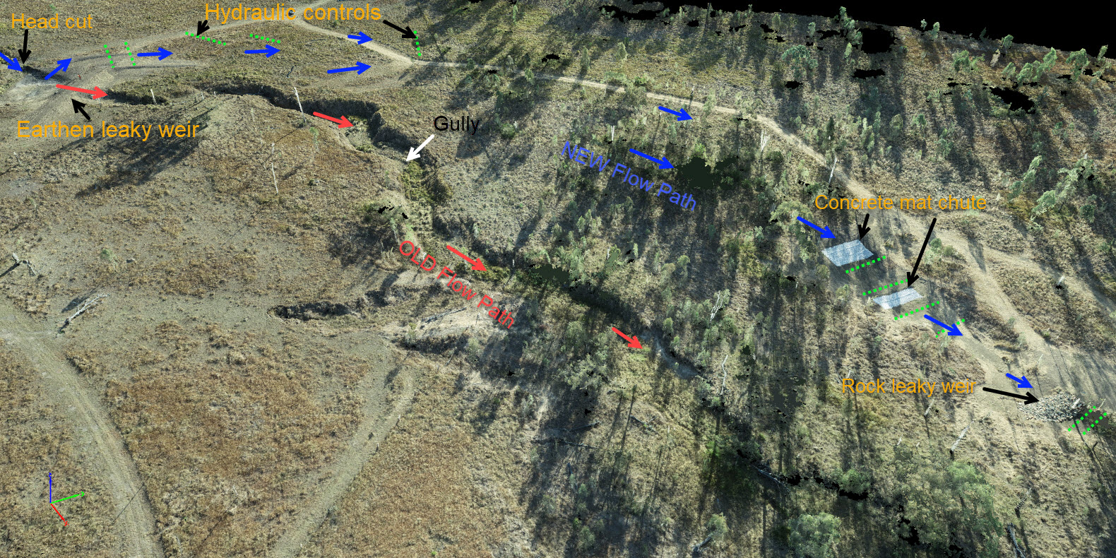
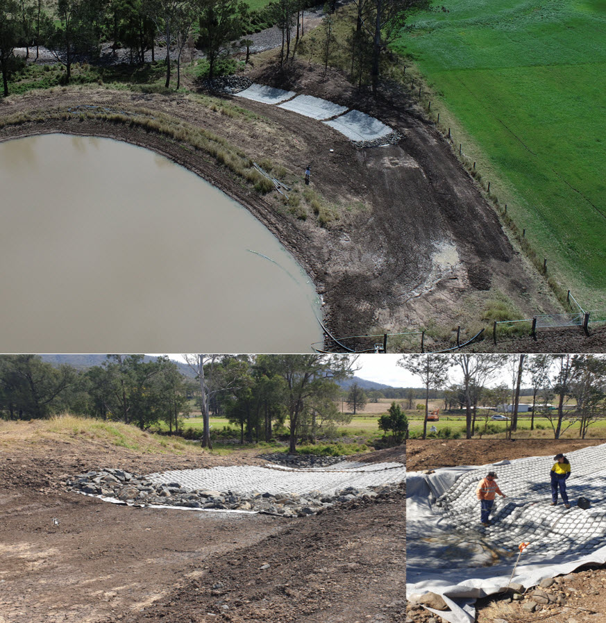
Our designs are derived from digital data captured using our own field-proven drone-based methods. We understand the strengths/limitations of our data and how to best utilize it to effectively inform the design process. 

Environmental Engineering
Field Experience

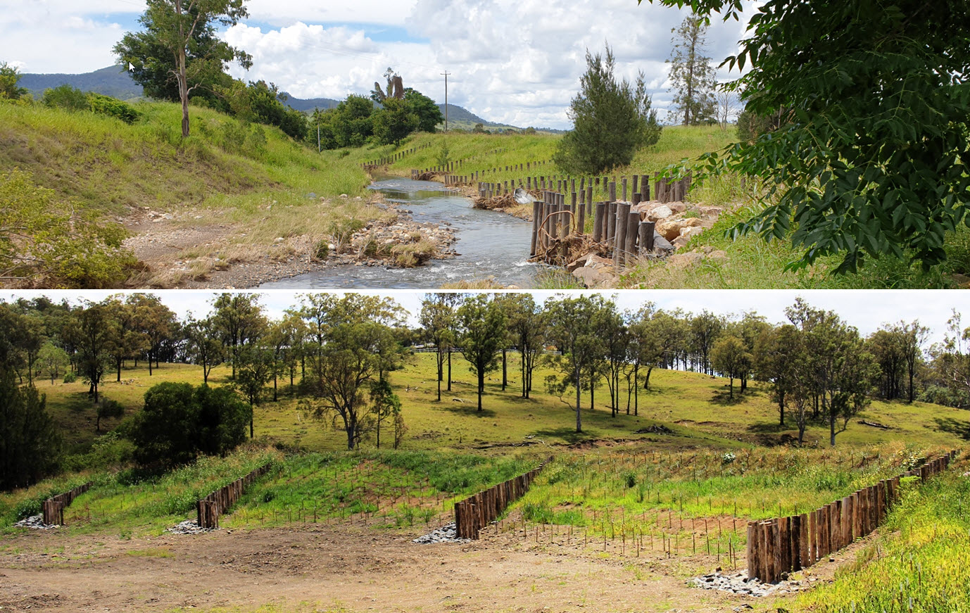
We understand when field inspections and in-field data can provide better value than purely digital data. This improves the engineering process and means our solutions can be implemented effectively in the real world.

Environmental Engineering
Hydrology Modelling

Robust hydrology modelling is derived from our fit-for-purpose 3d models of the environment and underpins our engineering designs.  We conduct flood modelling to support complex projects and assess afflux and flooding potential.

Environmental Engineering
Multidisciplinary Team

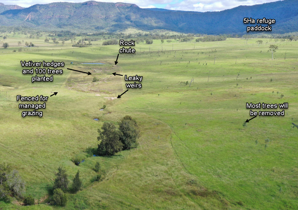
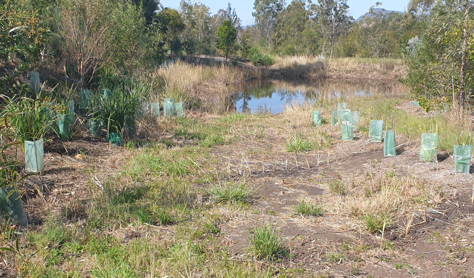
Input from our ecologists, engineers and GIS experts means we can provide innovative and sustainable solutions based on a more comprehensive understanding of complex environmental interactions.   

Environmental Engineering
Risk Management

We identify and mitigate risks early in the project planning phase.  Our ecologists assess environmental risks; environmental engineers evaluate technical risks and GIS experts analyze specialised data sets to predict potential hazards.

Environmental Engineering
Monitoring and Trend Analysis:

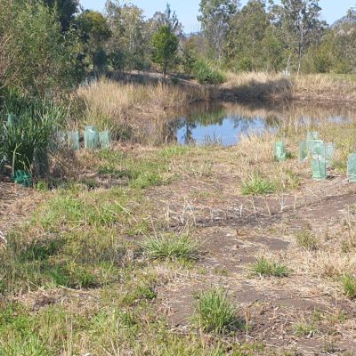
Our repeat surveys provide effective monitoring and trend analysis to track the performance of our solutions and detect changes in environmental parameters for sustainable outcomes.


AirBorn Insight bring professionalism, cutting edge technology and extensive experience. They capture the data we need and help analyse our complex natural environment so we can make better business decisions.

Mark Ward, Principal Restoration Innovation, Healthy Land & Water

AirBorn Insight are our go-to provider for aerial survey and imagery. They fully understand our needs and are excellent at what they do. I am always impressed with the quality and accuracy of their work, especially for repeat survey. I frequently recommend AirBorn Insight to my clients and stakeholders.

Dr Micheal Cheetham, Principal Scientist Water Technology


AirBorn Insight are a trusted collaborator of Bligh Tanner for survey and data collection on unique and often remote projects. We appreciate their professionalism and active involvement in projects to ensure that the data capture is reliable and will best achieve the project objectives

Riley Dejong, Civil and Water Engineer Bligh Tanner

Environmental Engineering

APPLICATIONS of Environmental Engineering

We have extensive experience assessing and stabilising river and gully erosion, providing both concept and detailed designs for repairs. Using high precision sensors, we can accurately scan project sites and identify the most appropriate solution. Our erosion control projects vary from large industry/government funded projects with multiple earthworks contractors, to small private projects where landholders implement erosion control solutions themselves.  We focus on optimizing land management practices where ‘cover is king’, hence vegetation is key element of all the design work we undertake. 

Engineered Log Jams for bank stabilisation

Pile Fields for bank stabilisation

Rock Chutes for instream and gully head wall repair

Concrete Mat Chutes for gully head wall repair

Vetiver Chutes for gully head wall repair

Contour design for hillslope and gully erosion

Refuge Gully implementation

Wetland reinstatement

Riparian weed control projects

Dams

Leaky weirs

Airborn Insight is a thought leader in landscape improvement using gully restoration. In these projects we engineer repairs of gully head wall erosion and install small leaky weirs across gullies.  Gully refuge paddocks are a key tool for landscape management and are reversing the trend of desertification in Australia. Not only have they proven to provide pasture for stock in dry times, but they also reduce sediment loss and encourage sediment deposition by changing landscape hydrology.  Gully refuge paddocks also provide multiple and ever improving NRM outcomes, such as native habitat, denser and more diverse pastures and vegetation.  These revegetated gully corridors then connect the local creek with its upper catchment ridge line providing an ecological highway for animals and plants. 

We can provide valuable insights into these dynamic and often unpredictable natural phenomena. By deploying state of the art airborne systems, we can undertake accurate flood modelling, better predicting river and flood plain response to storm events.  This information is vital for effective design of flood risk management and mitigation strategies.

We capture precise topographic data for detailed analysis of slopes, elevation, and surface characteristics. Integrating hydrological data, such as water flow patterns, drainage networks, and water storage capacity, further enhances our understanding of the hydrological processes within the landscape. These models facilitate better engineering for our projects.

Project Gallery

Environmental Engineering

Environmental Engineering FAQ

PLAN OF WORKS AND DETAIL DESIGNS. These documents include detail design of the earthworks, revegetation and maintenance requirements.  A critical element of the engineered solution is the design and specification for revegetation (spacing, species, angle of planting). While often seen as less important, it must be an integral part of the solution for sustainable landscape restoration.

SITE SET OUT AND CONSTRUCTION OVERSITE. It is vital that the site set-out is conducted together with earthworks contractors to ensure clarity on design and project requirements.  Oversight of project construction by our engineers ensures design specifications are achieved in the field for long-term project success and avoids costly errors requiring rework. 

VEGETTAION AND MAINTENANCE OVERSIGHT. Revegetation placement and establishment is critical. Supervision during installation is required to ensure vegetation is correctly placed and is maintainable for hydraulic effectiveness. This requires set out of the revegetation design and a site conformance inspection after planting.

Engineered log jams are an innovative solution to combat erosion along creek and riverbanks. These structures consist of strategically placed logs that serve multiple purposes. They are effective at stabilizing eroding shorelines, reducing the scouring of banks, and preventing sediment transport downstream. Engineered log jams also provide essential habitat enhancements in aquatic ecosystems. By creating sheltered areas and increasing habitat complexity, they foster the growth of vegetation and provide refuge for fish and other wildlife.

Pile fields are a robust method for preventing erosion and protecting infrastructure along creek and riverbanks. These wooden or steel structures are driven into the banks, reinforcing them and reducing soil loss. Pile fields can be tailored to the specific needs of a location and are versatile in their application. By preventing further bank erosion and providing stability, they play a crucial role in safeguarding the infrastructure and the environment.

Leaky weirs are hydraulic structures designed to manage water flow in a controlled manner by allowing controlled seepage through the structure. These weirs are effective at mitigating erosion by dissipating the energy of flowing water. They also provide benefits such as facilitating fish passage, promoting oxygenation of the water, and improving water quality. By allowing a controlled amount of water to seep through, leaky weirs are versatile tools in water management and environmental conservation, contributing to the overall health of aquatic ecosystems.

Rock chutes are engineered structures placed in watercourses to address erosion and sediment transport issues. They are particularly effective in stabilizing gully head walls, reducing soil loss, and protecting sensitive areas from further degradation. Rock chutes vary in design but generally consist of rocks or other materials that break up the flow of water, reducing its erosive force. By controlling sediment transport and mitigating erosion, these structures contribute to the preservation and protection of waterways, helping to maintain ecological balance in sensitive environments.

Vetiver grass is a natural solution for reducing erosion in gully head walls. Its extensive root systems help bind soil, stabilize banks, and prevent further gully development. Vetiver chutes involve planting this grass in gully head walls, offering an eco-friendly and sustainable way to address erosion issues and promote environmental conservation.

Contour design is a land management strategy that focuses on sustainable land practices and drainage control. By planning land use to follow the contours of the landscape, it reduces erosion on hillslopes and in gullies. This approach not only minimizes soil loss but also contributes to overall environmental sustainability by preventing degradation and promoting responsible land practices.

These projects aim to manage and eradicate invasive plant species along riparian areas, which are the zones along the banks of water bodies. Invasive species can disrupt native ecosystems, affect water quality, and reduce habitat for wildlife. Riparian weed control initiatives help maintain healthy riparian zones, which are vital for water quality, biodiversity, and the overall health of aquatic environments. These projects are a key component of environmental conservation efforts.

Refuge gullies are designed to capture and store water during heavy rainfall events, reducing downstream flooding. These structures help control water flow and protect vulnerable areas. They are especially useful in regions prone to extreme weather events, as they can mitigate the impact of flooding and prevent damage to infrastructure and ecosystems.