

AERIAL DATA TO MAKE BETTER DECISIONS
Drone-based
Environmental Monitoring
AirBorn Insight combines expert environmental knowledge with high-performance equipment, robust methodologies, and in-house data processing to deliver a first-class experience in drone-based environmental monitoring. Our qualified science and engineering professionals provide precise data and analysis for environmental management decisions and actionable recommendations. Our services extend to environmental engineering solutions with RPEQ certification.
Drone based
Environmental Monitoring
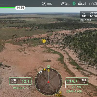
EROSION MANAGEMENT FROM ABOVE
Drone-based environmental monitoring has numerous applications across different fields. It can aid in ecosystem management, conservation efforts, disaster response, urban planning, agriculture, and infrastructure development. By providing accurate and up-to-date information, drones enable more effective and efficient environmental monitoring, leading to better resource management, protection of ecosystems, and informed decision-making for sustainable development.

Drone based Environmental Monitoring
We streamline compliance reporting by providing accurate, repeatable, and highly visual data. This improves transparency, ensures compliance, and facilitates regulatory reporting obligations with confidence.
Precise positioning and control capabilities of our industry-leading drone systems ensure accurate and consistent data collection, reducing errors and enhancing the quality of environmental datasets.
Our repeat surveys facilitate long-term monitoring and trend analysis. This allows for the detection of changes and patterns in environmental parameters, aiding in understanding and managing environmental issues.
With the ability to capture high-resolution imagery and sensor data efficiently, our airborne systems facilitate detailed monitoring of environmental parameters across diverse landscapes.
Our services provide cost savings by minimizing ground-based surveys and eliminating the need for manned flights for small and medium areas, making environmental monitoring more accessible and affordable.
By replacing manual fieldwork with drone-based environmental monitoring, risks to personnel in hazardous or inaccessible environments are significantly reduced.
Our airborne systems can integrate multiple data sources such as thermal imaging, multispectral or LiDAR. This comprehensive approach provides valuable insights for environmental assessments.
Our drone-based environmental monitoring services are ideal for monitoring remote or difficult-to-reach locations, including rugged terrain, dense vegetation, or water bodies.
AirBorn Insight are our go-to provider for aerial survey and imagery. They fully understand our needs and are excellent at what they do. I am always impressed with the quality and accuracy of their work, especially for repeat survey. I frequently recommend AirBorn Insight to my clients and stakeholders.
Dr Micheal Cheetham Principal Scientist, Water TechnologyAirBorn Insight are a trusted collaborator of Bligh Tanner for survey and data collection on unique and often remote projects. We appreciate their professionalism and active involvement in projects to ensure that the data capture is reliable and will best achieve the project objectives.
Riley Dejong Civil and Water Engineer, Bligh TannerDrone based Environmental Monitoring


Drone Survey and Aerial Mapping
APPLICATIONS OF OUR DRONE ENVIRNOMENTAL MONITORING
Drone-based environmental monitoring combines the capabilities of drones and advanced sensors to gather essential environmental data, contributing to a better understanding of our surroundings and supporting efforts towards a more sustainable and resilient future.
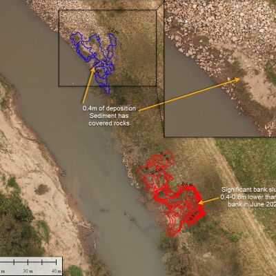
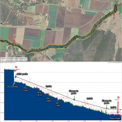
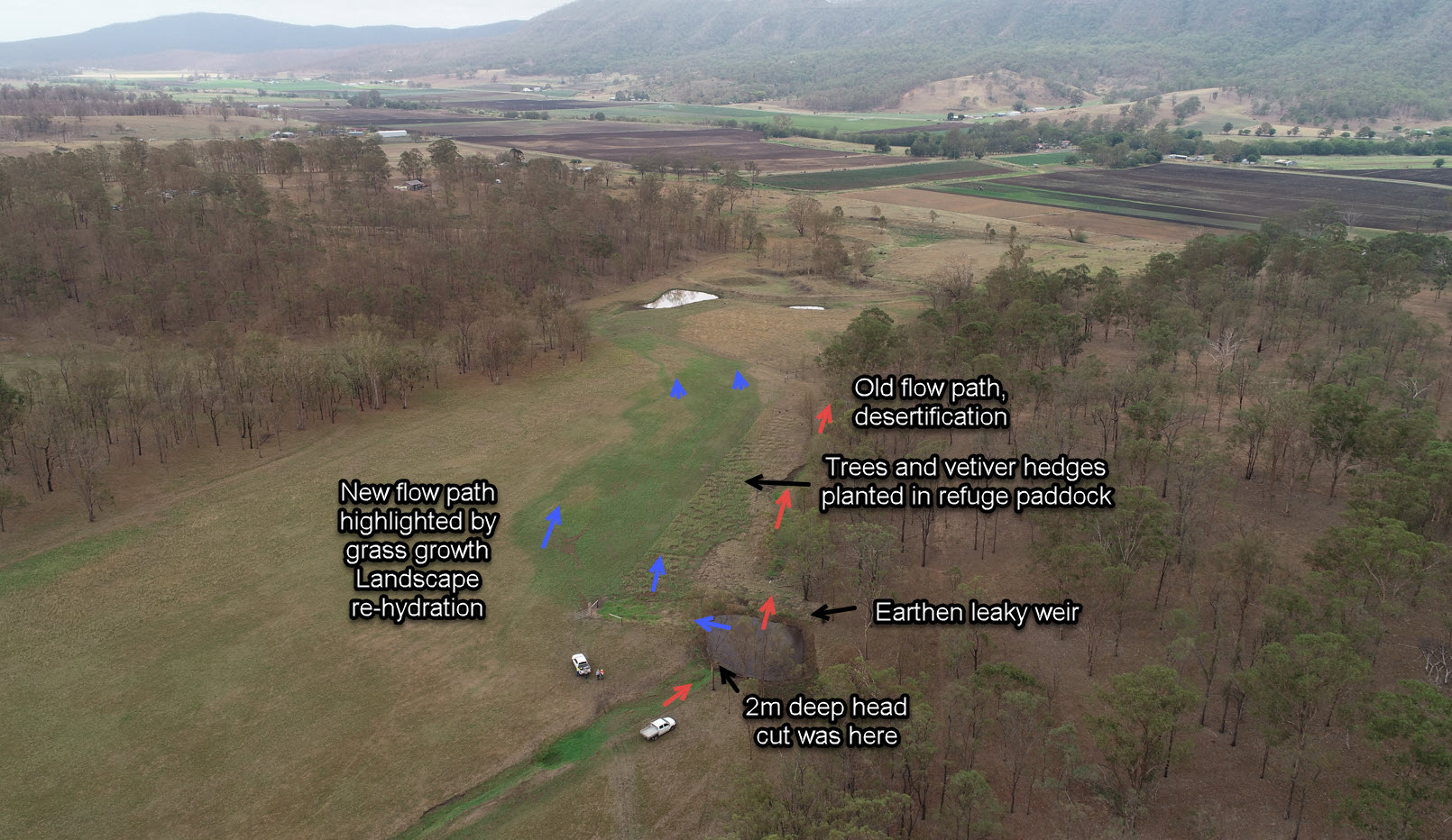
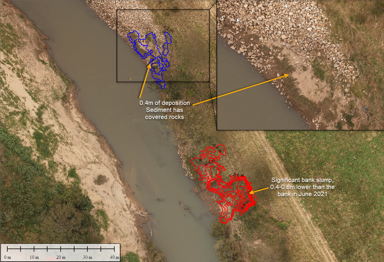
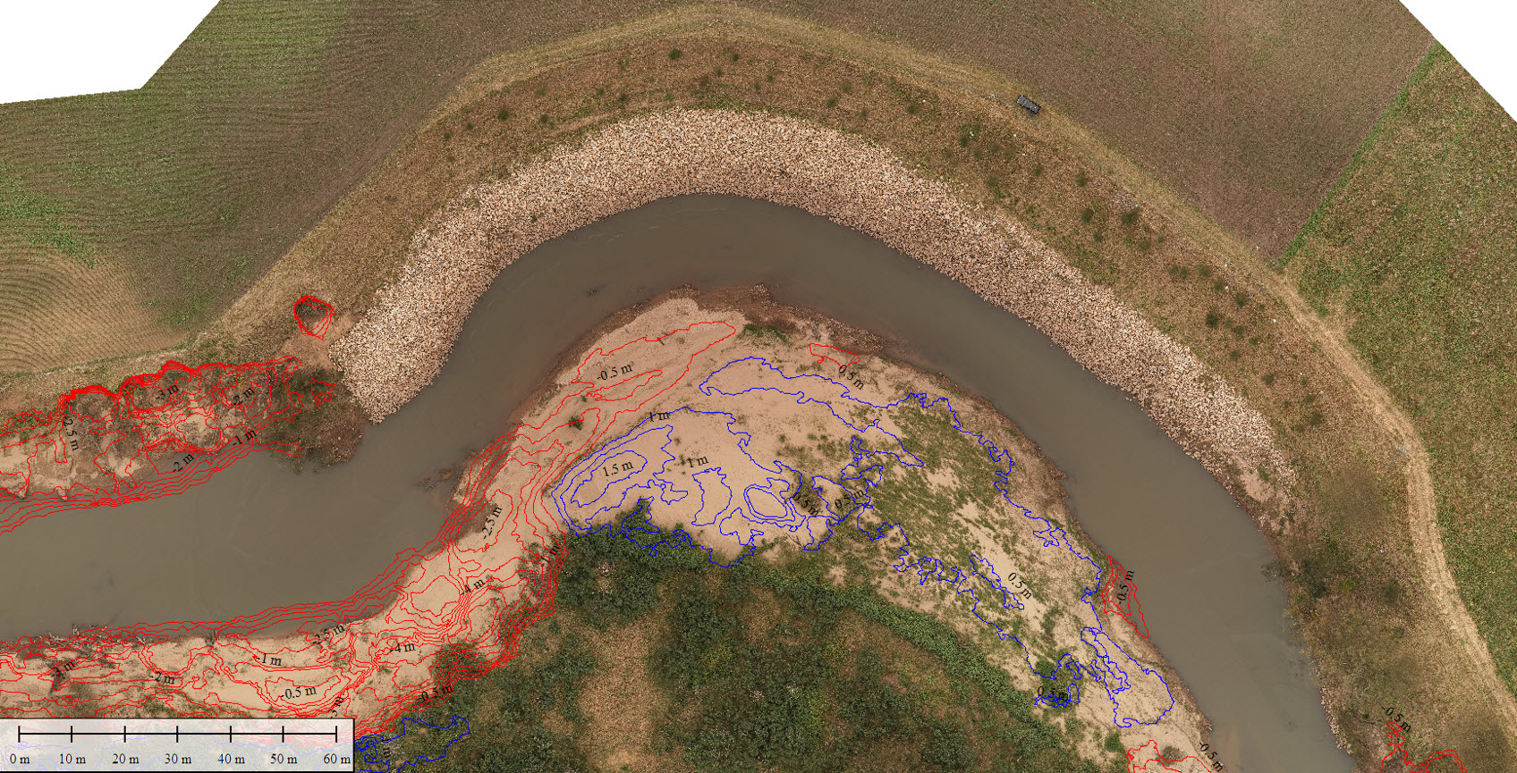
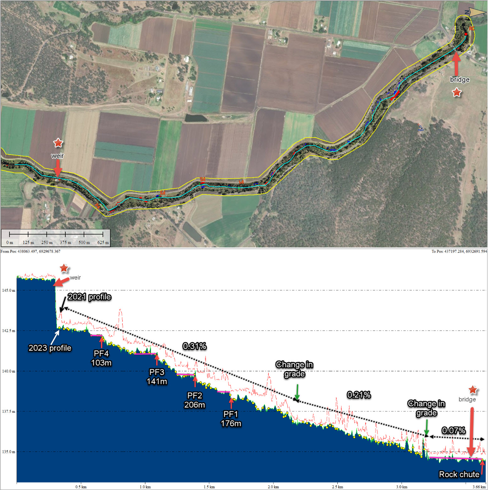
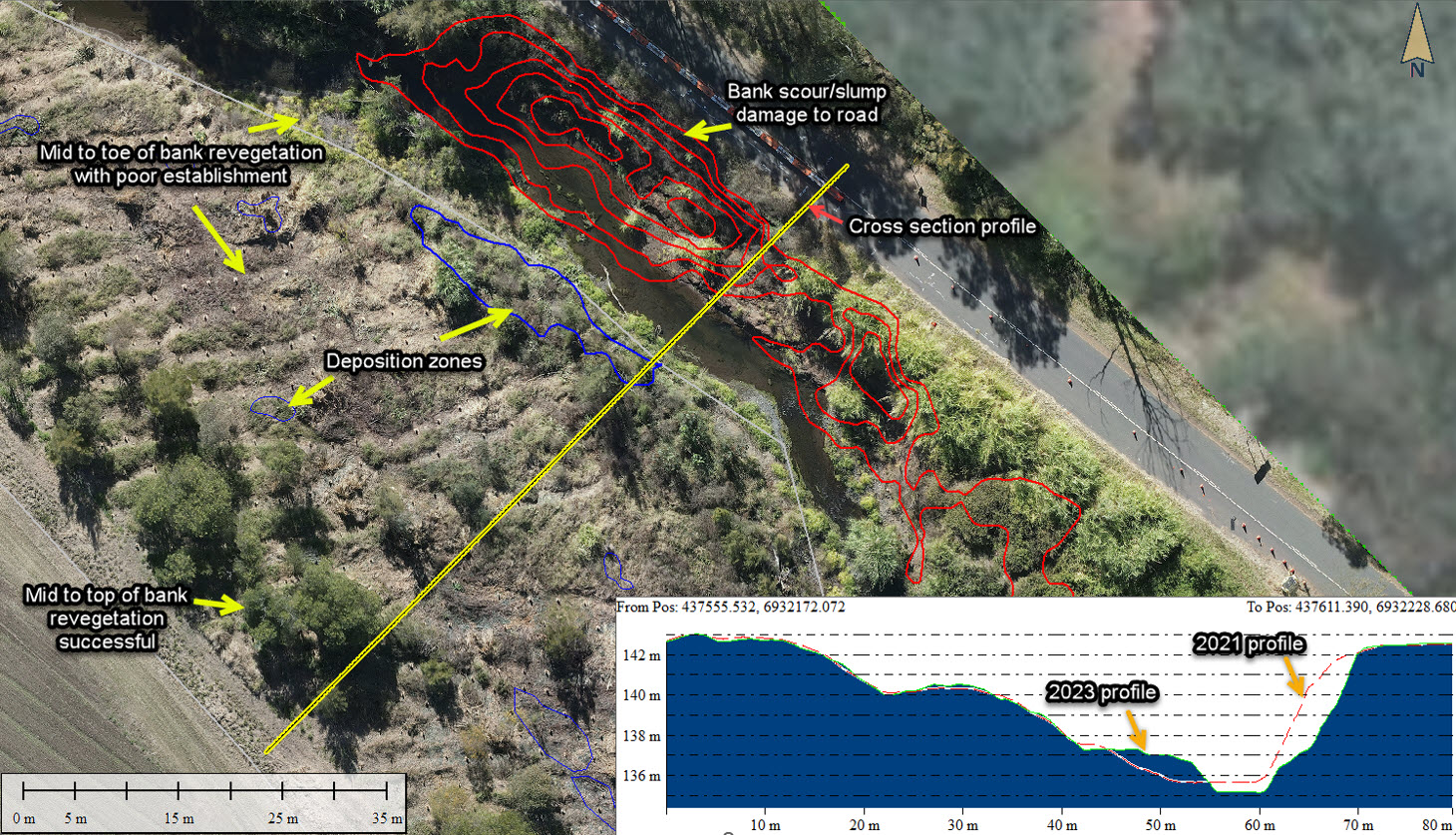
We have extensive experience assessing and monitoring river and gully erosion, providing valuable data for erosion control and land management. Using high-precision cameras and sensors, we can accurately monitor erosion rates, identify areas at risk of erosion, and assess the impact on surrounding ecosystems. By regularly monitoring river and gully erosion, our drone-based environmental monitoring services help in the development of effective erosion control strategies, optimize land management practices, and protect vulnerable areas from further degradation. This information aids in understanding the dynamics of erosion processes, guiding conservation efforts, and promoting sustainable land use practices.
Our RPEQ certified engineers have designed and implemented countless erosion control projects over the past 15 years. Our drone surveys play a crucial role in informing engineering designs by enabling us to clearly identify vulnerable areas and to design and model effective solutions. By monitoring erosion patterns, we can design, implement and evaluate the effectiveness of new and existing control measures and land management practices. Our services facilitate compliance with environmental regulations, promote responsible land development practices, and contribute to the long-term preservation of our environment.
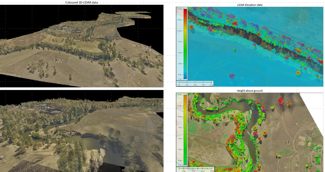
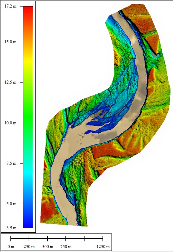
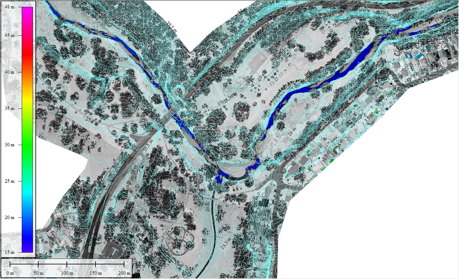
We can provide valuable insights into these dynamic and often unpredictable natural phenomena. By deploying state-of-the-art airborne systems, we monitor river channels, identify erosion hotspots, assess flood damage, and evaluate the effectiveness of flood management measures. The captured data also allows for accurate flood modelling, better prediction of flood events, and informed decision-making for flood risk management and mitigation strategies. Our expertise in drone-based environmental monitoring ensures precise and reliable assessments of river and flood dynamics, contributing to more effective flood management and increased resilience in flood-prone areas.
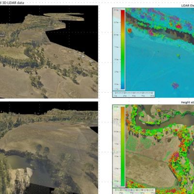
We capture precise topographic data for detailed analysis of slopes, elevation, and surface characteristics. Integrating hydrological data, such as water flow patterns, drainage networks, and water storage capacity, further enhances our understanding of the hydrological processes within the landscape. These models facilitate informed decision-making in various fields, including land development, flood management, and water resource planning. Our experience in aerial survey and mapping means we can provide reliable terrain and hydrology models that contribute to sustainable land management and effective water resource management.
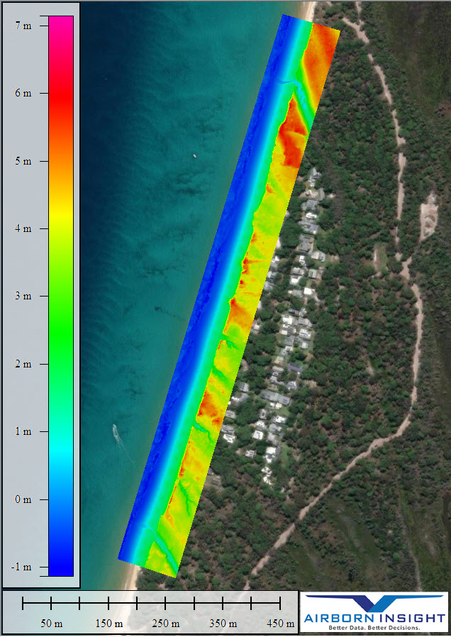
Our environmental monitoring services enable precise and efficient monitoring of coastal erosion, sedimentation, and shoreline changes. By conducting aerial surveys and capturing high-resolution imagery, we gather critical data for assessing erosion rates, identifying vulnerable areas, and developing effective coastal management strategies. Our services contribute to understanding coastal dynamics, guiding planning decisions, and safeguarding vulnerable coastal regions from erosion impacts.
Our drone-based environmental monitoring services can play an important role in the preservation and management of these vital ecosystems. Our airborne systems collect data on vegetation health and habitat conditions within riparian areas. By monitoring riparian zones, we can identify changes in vegetation cover, detect invasive species encroachment, and assess the impact of human activities on these sensitive habitats. This information assists in developing effective conservation and restoration strategies, promotes sustainable land use practices along waterways, and safeguards the ecological integrity of riparian ecosystems.
Our drone-based environmental monitoring services extend to precision agriculture, focusing on monitoring crop health, growth patterns, and irrigation needs. Equipped with scientific-grade multispectral and thermal cameras, our drones systems can detect nutrient deficiencies, pest infestations, and disease outbreaks early on. By providing farmers with data-driven insights, we optimize resource allocation, enhance sustainable crop management practices, and maximize crop yields while minimizing chemical inputs.
Our services include mapping and monitoring of wetland ecosystems, tracking changes in vegetation, water levels, and wildlife habitat. We aid wetland restoration efforts by assessing the success of restoration projects, monitoring water quality, and identifying invasive species that pose a threat. By providing comprehensive data, we help inform conservation strategies, improve wetland management practices, and contribute to the preservation of these valuable ecosystems.
We support ecological restoration projects by capturing data on vegetation coverage, ecosystem health, and biodiversity indicators using advanced imaging technologies. This information is crucial for assessing the effectiveness of restoration interventions, identifying areas requiring additional attention, and making informed decisions for future restoration activities. Our cost-efficient and scalable drone-based environmental monitoring services enable stakeholders to evaluate ecological recovery, adapt management strategies, and promote the resilience of ecosystems.
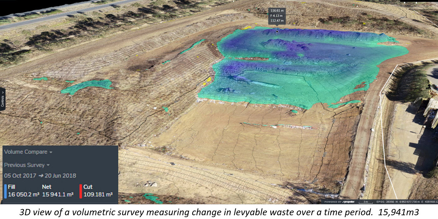
Our landfill mapping and monitoring services assist managers to improve the performance of their sites by using powerful 3D visualisation and analytics for enhanced decision making. Our services include volumetric surveys of levyable waste disposal sites and RRA, topographical plans, airspace calculations, stockpile volumes, waste compaction density calculations and tracking of cell fill-up against fill plans. We provide independent third-party volume calculations for compliance reporting. Our surveys are certified accurate by registered surveyors and fulfill requirements of Waste Levy legislation. We supply drawings / plans / volumes in the required formats.
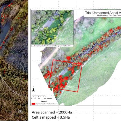
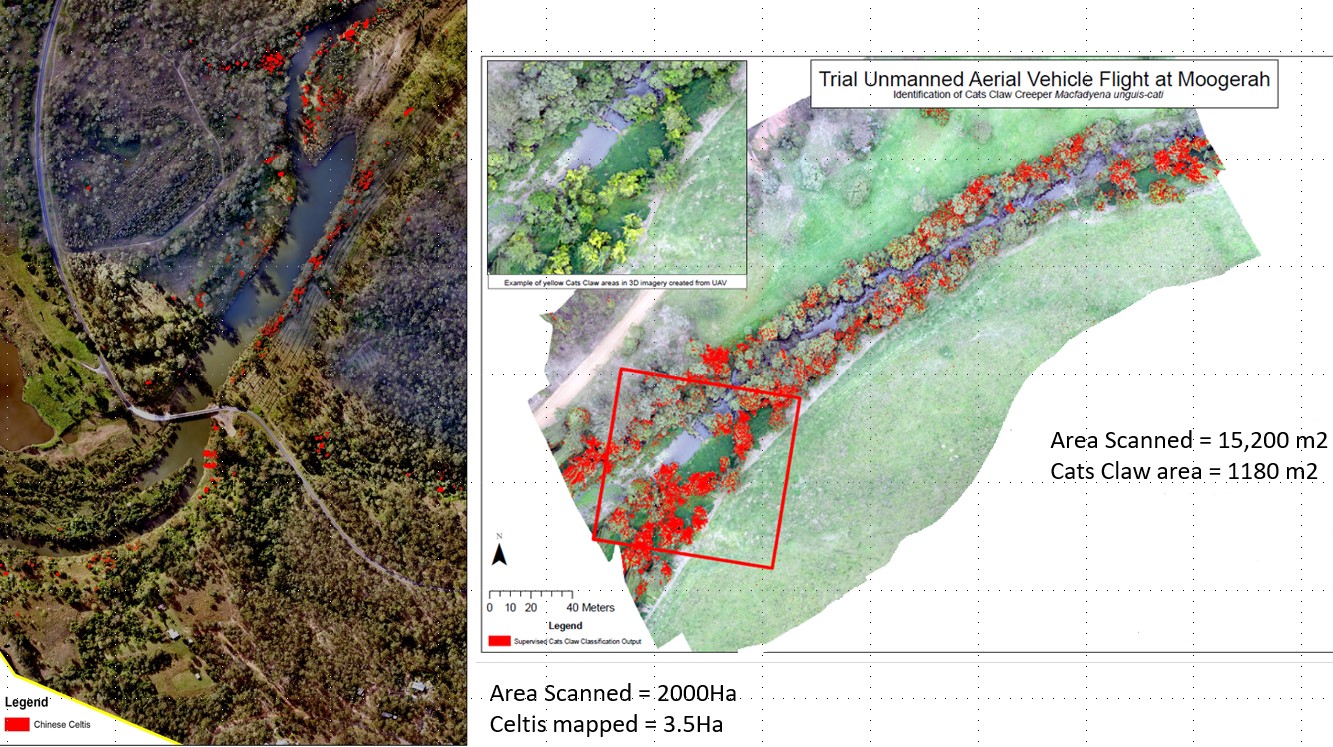
With our advanced sensors and in-house data analytics, we can identify vegetation patterns, detect invasive species, and assess the extent of infestations. This information enables targeted control measures, such as precision herbicide application or manual removal, to prevent the spread of invasive species and protect native ecosystems. Our drone-based environmental monitoring services provide a rapid and cost-effective means of surveying large areas, enabling efficient and proactive management of invasive species, ultimately preserving the biodiversity and ecological balance of ecosystems.
We deploy drones to monitor mine sites for compliance with environmental regulations, map mine rehabilitation progress, and assess the impact of mining activities on surrounding ecosystems. Equipped with advanced sensors such as multispectral and LiDAR (laser), our drones conduct topographic surveys and monitor changes in land cover. They provide a cost-effective and efficient means of monitoring mine sites, allowing for regular inspections, early detection of environmental issues, and accurate documentation of reclamation efforts.
Drone based Environmental Monitoring
We have a strong reputation in drone-based environmental monitoring, supported by positive client references. Our qualified professionals offer expert environmental knowledge for informed decision-making. Our comprehensive project management includes precise surveys, in-house data processing, and detailed reporting. We utilize advanced drone technology and data analysis capabilities to deliver accurate results. Timeliness and efficiency are prioritized, and we provide customization and flexibility to meet project requirements. Compliance and safety are paramount, ensuring responsible monitoring practices.
Drone based Environmental Monitoring
Drones can measure vegetation health, water quality, air pollution, temperature, humidity, land cover, wildlife populations, erosion rates, and more, depending on the sensors and instruments attached.
Operators must obtain necessary CASA licenses and insurances, comply with local regulations, adhere to privacy laws, ensure safe flight operations, and respect protected areas and wildlife habitats.
Challenges include regulatory restrictions, limited flight time, weather conditions affecting flight operations, and the need for skilled operators and data analysis expertise.
Challenges include regulatory restrictions, limited flight time, weather conditions affecting flight operations, and the need for skilled operators and data analysis expertise.
Advancements in technology and improved regulations are expected to expand the applications of drones, allowing for more accurate, efficient, and widespread environmental monitoring to address pressing environmental challenges.