

AERIAL DATA TO MAKE BETTER DECISIONS
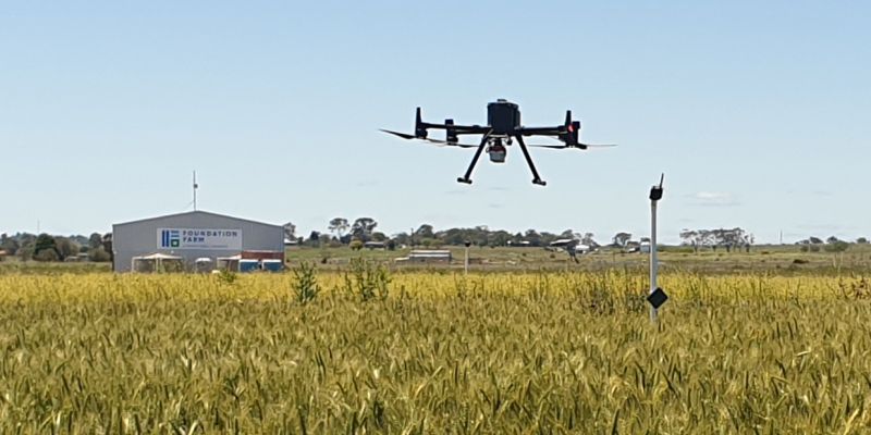
Drone-based Phenotyping for Agriculture Field Trials
AirBorn Insight has an established track record of providing high quality phenotype data to leading universities, research organisations and plant breeders in Australia since 2015. Our unique and comprehensive project management approach ensures quality data from start to finish. We combine technical expertise and high-performance equipment to deliver a first-class experience in done-based phenotyping for agricultural field trials.
Drone based phenotyping
PLANT DATA FROM ABOVE
Drone-based phenotyping is an innovative approach in agriculture that utilizes unmanned aerial vehicles (UAVs) equipped with sensors and cameras to collect data on plant traits. It involves the systematic and automated acquisition of high-resolution imagery, multispectral or hyperspectral data, and other relevant measurements from crops or experimental plots. This data is then analysed to understand plant health, growth patterns, stress responses, and other phenotypic characteristics. By providing detailed and precise information about crops, drone-based phenotyping enables researchers and farmers to make data-driven decisions regarding breeding programs, crop management practices, and resource optimization.

Drone based phenotyping

Our drone-based phenotyping services enable the capture and analysis of new plant traits, providing researchers with deeper insights into crop characteristics and performance.
By capturing multiple traits simultaneously and at scale, our services significantly improve the efficiency of phenotyping efforts, saving time and resources for researchers and breeders.
Rapid data capture using drones helps reduce environmental variability, leading to more accurate and reliable phenotypic measurements for precise analysis and decision-making.
With our non-invasive approach, we eliminate plant disturbance, allowing for repeated measurements over time without impacting plant growth or development, ensuring reliable and consistent data collection.
Manual ground-based measurements can sometimes involve human error, but our drone-based approach minimizes such errors, providing more reliable and consistent data for analysis and interpretation.
Our services merge drone phenotypic data with agricultural datasets, enabling comprehensive analysis for enhanced research insights and improved crop performance.
The services provided by AirBorn Insight have supported a number of advances in crop research at The University of Queensland. They understand field research and the need to deliver. This takes the stress out of research as we can rely on them to provide high quality data
Professor Lee Hickey Centre for Crop Science, QAAFI, University of QueenslandAERIAL DATA TO MAKE BETTER DECISIONS
WHY USE AIRBORN INSIGHT FOR
DRONE-BASED PHENOTYPING?
Expert Consultation, Precise Capture, and Reliable Data Processing for Research Success
Our science and engineering professionals take responsibility for our projects from initial flight planning through to final data outputs. This avoids information gaps and hand-over errors that can occur when multiple parties get involved with mixed experience. Our end-to-end workflows ensure repeatable, high-quality outcomes – we design optimum flight protocols tailored to each sensor’s specifications, monitor environmental conditions during capture, perform in-field calibration, conduct professional piloting, analyse imagery, and provide statistical data in a usable format.
Achieve Your Project Objectives with Expertise, Safety, and Hassle-Free Operations
As an experienced provider of drone-based phenotyping services, we can achieve the right outcome, first time, under a proven safety management system. We offer immediate deployment while taking care of costly equipment and the complexities of drone operations – training, maintenance, aviation safety management, documentation and liability. We can achieve the outcome you need so you can achieve your project objectives efficiently.
Minimizing Variability and Enhancing Research Insights
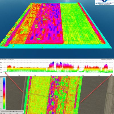
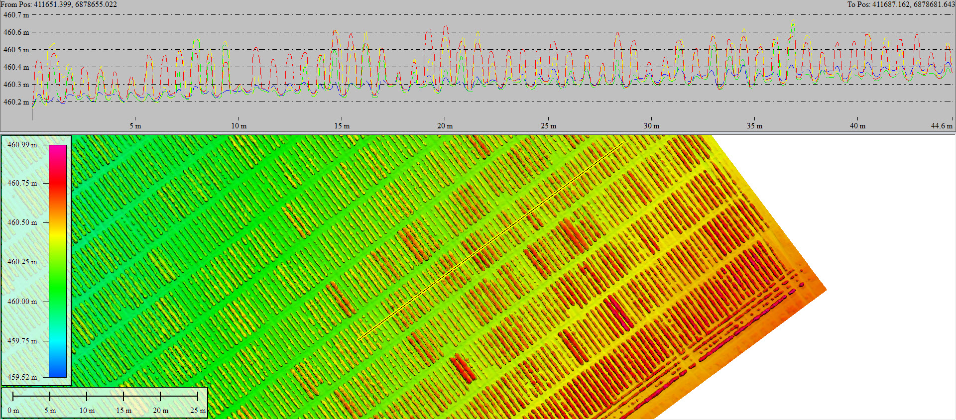
Our high-performance systems enable efficient and uninterrupted data capture over large areas, minimising environmental variability. Our research-grade sensors include discrete band multispectral imagers, calibrated LWIR radiometric thermal sensors, precision laser scanners and ultrahigh-resolution cameras for machine learning object detection. Our ground survey equipment ensures precise geo-referencing for accurate comparison over time, down to the individual plant or leaf level.
Technical Expertise, Scientific Rigor, and Environmental Considerations for Quality Data
Acquiring quality phenotype data for agricultural field trials requires more than simply flying a drone. We apply technical understanding of sensor and software limitations, and ensure strict adherence to scientific procedures. Monitoring environmental conditions before and during data capture is vital, and effective sensor calibration is critical. We prioritize meticulous attention to detail to maximize data quality and validity.
Accurate Results through Quality Assurance and Environmental Monitoring
AirBorn Insight has been providing quality phenomic data processing services to leading research institutions since 2015. Captured data is meticulously checked prior to processing, and we ensure calibration procedures have been correctly applied. Our in-house data processing is not blindly automated to the detriment of accuracy – quality assurance checks are undertaken, and environmental conditions that are monitored during data capture are accounted for during processing. In addition to being highly visual, our statistical data is provided in an easily digestible and useable format.
Empowering Researchers to Analyse, Visualise, and Collaborate for Enhanced Phenotyping Discoveries
Our interactive data platforms enable researchers to explore and analyse large datasets in a user-friendly and intuitive manner. By providing interactive visualisations, researchers can delve into specific aspects of the data, zoom in on areas of interest, and manipulate variables for deeper insights. This facilitates the identification of patterns, trends, and correlations, aiding in the understanding of plant traits, growth patterns, and environmental influences. Interactive data viewing also promotes collaboration, as multiple stakeholders can interact with the data, share observations, and collectively derive meaningful conclusions for enhanced decision-making in agricultural research and breeding programs.
Drone based phenotyping
AGRICULTURAL FIELD TRIALS?

High Resolution Imagery for machine learning
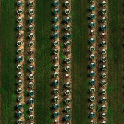
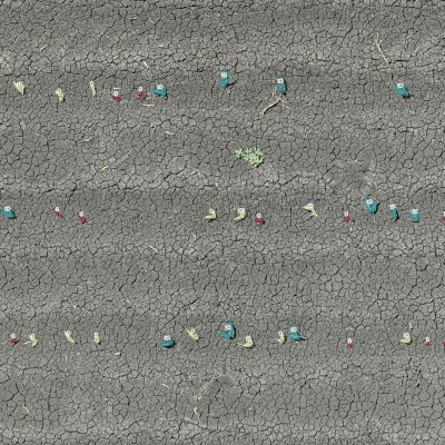
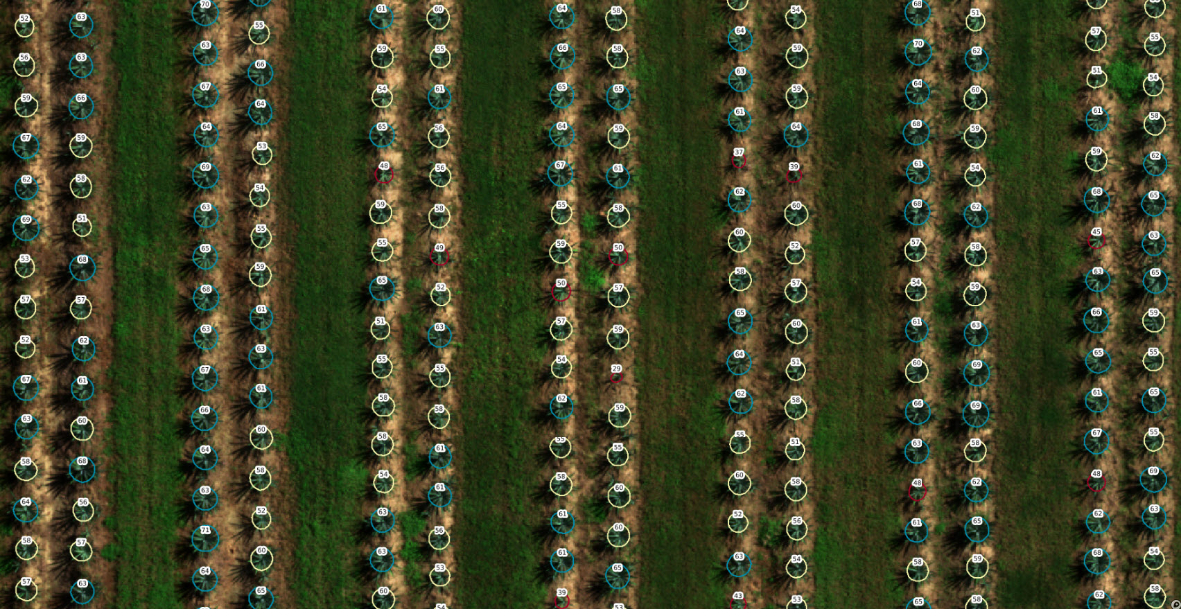
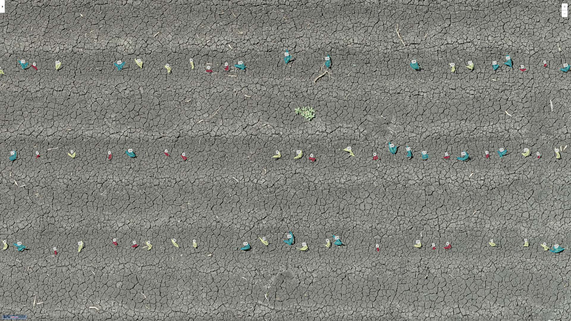
Plant counting at micro-plot or paddock level
Plant size classification
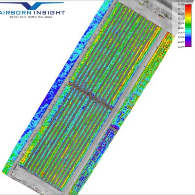
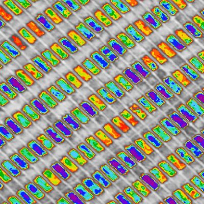
Multispectral Indices
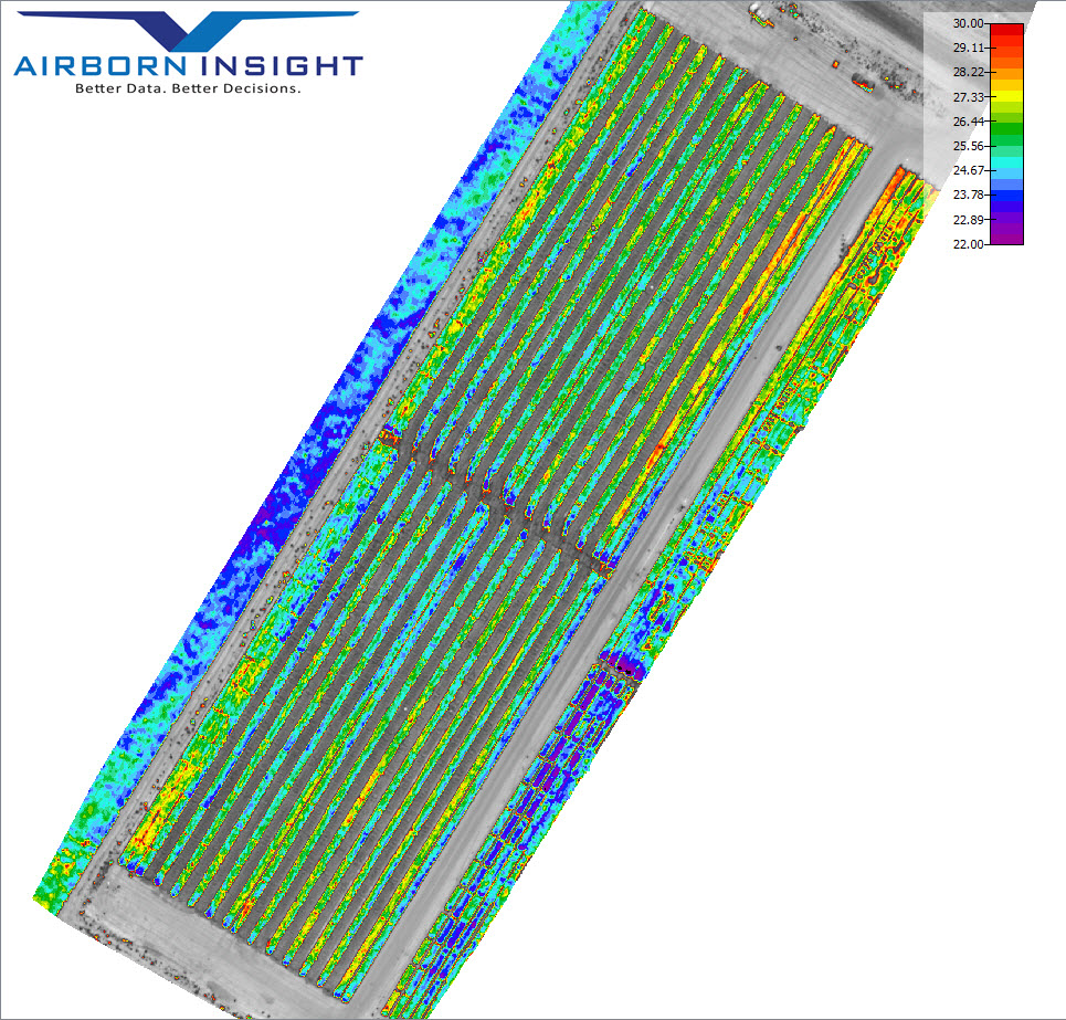
Calibrated Radiometric Thermal data
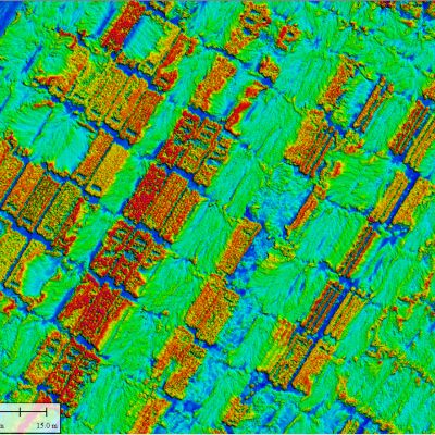
Plant heights via precision laser scan


Our plant data is used to accelerate the development of superior varieties and products. This is achieved with accurate and repeatable data by (1) utilising high-performance drone systems and research grade sensors (2) applying in-depth understanding of sensor and software capabilities/limitations and (3) strict adherence to scientific procedures for data capture and analytics
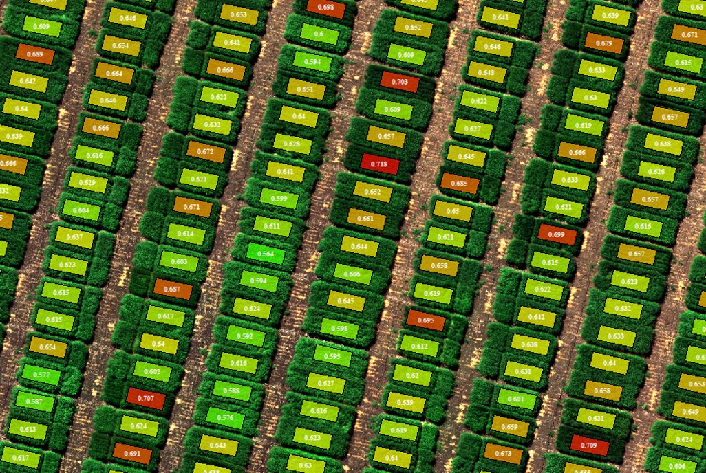
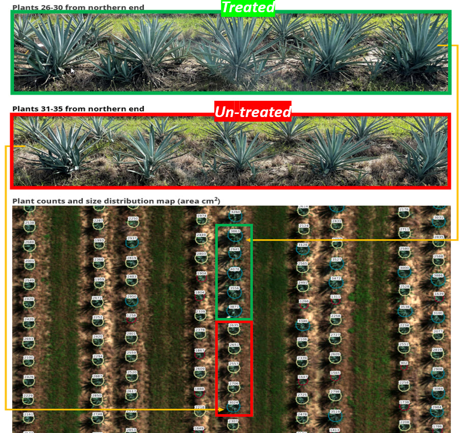
Counting and sizing plants in agricultural plot trials allows researchers to assess plant populations and evaluate establishment success. By knowing accurate plant counts, they can analyse germination rates, seed viability, and identify any gaps in the planting process. Sizing plants also provides insights into growth patterns, biomass accumulation, and crop development over time. This information helps researchers determine the effectiveness of different treatments, breeding programs, or environmental conditions on plant growth. Additionally, plant size measurements aid in yield estimation, optimizing crop management practices, and making data-driven decisions for improving agricultural productivity and ensuring the success of plot trials. AirBorn Insight deploys advanced, high-resolution imaging systems and techniques to achieve accurate plant count and size measurements. High quality imagery is vital for AI and machine learning success.
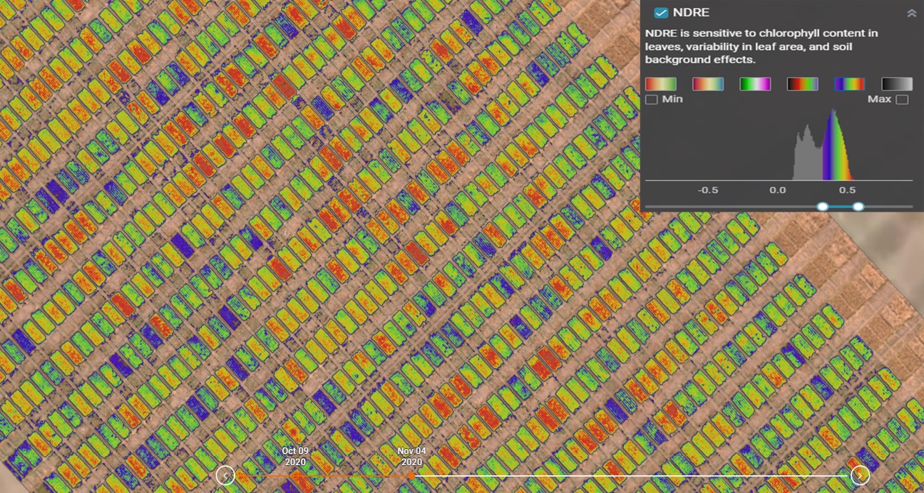
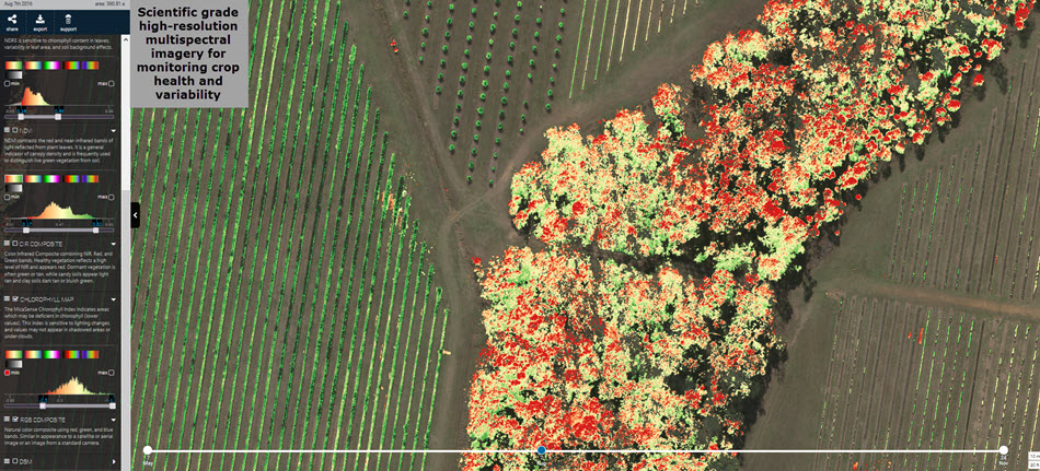
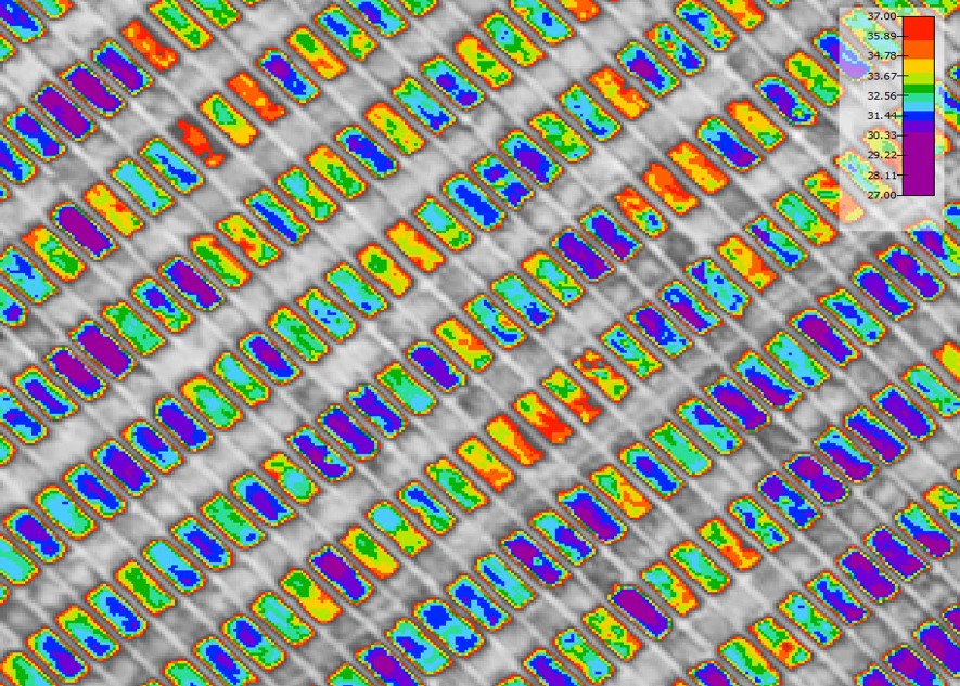
Multispectral data enables researchers to monitor and analyse various parameters such as crop health, growth patterns, nutrient status, and stress responses. By collecting data across different spectral bands, it provides valuable insights into plant performance, allowing for early detection of issues such as nutrient deficiencies, disease outbreaks, or water stress. Multispectral data can be used to generate vegetation indices, such as NDVI, to quantify plant vigor and biomass. This information aids in making informed decisions regarding treatment efficacy, resource allocation, and optimizing crop productivity in agricultural plot trials. AirBorn Insight uses scientific-grade multispectral sensors that are field calibrated for each capture for accurate and repeatable results.
Canopy temperature data provides valuable insights into plant water status and stress levels, aiding in irrigation management and water conservation efforts. It also highlighting areas of potential concern such as disease hotspots or inefficient nutrient uptake. Additionally, canopy temperature data in plot trials can assist in assessing crop performance under different environmental conditions, facilitating the selection of more resilient and climate-adaptive varieties. Thermal data is notoriously difficult to collect accurately due to inherent thermal drift within the sensor. This can be overcome with robust procedures and advanced sensors that externally calibrate regularly during aerial data capture. AirBorn Insight has extensive experience in thermal data capture.
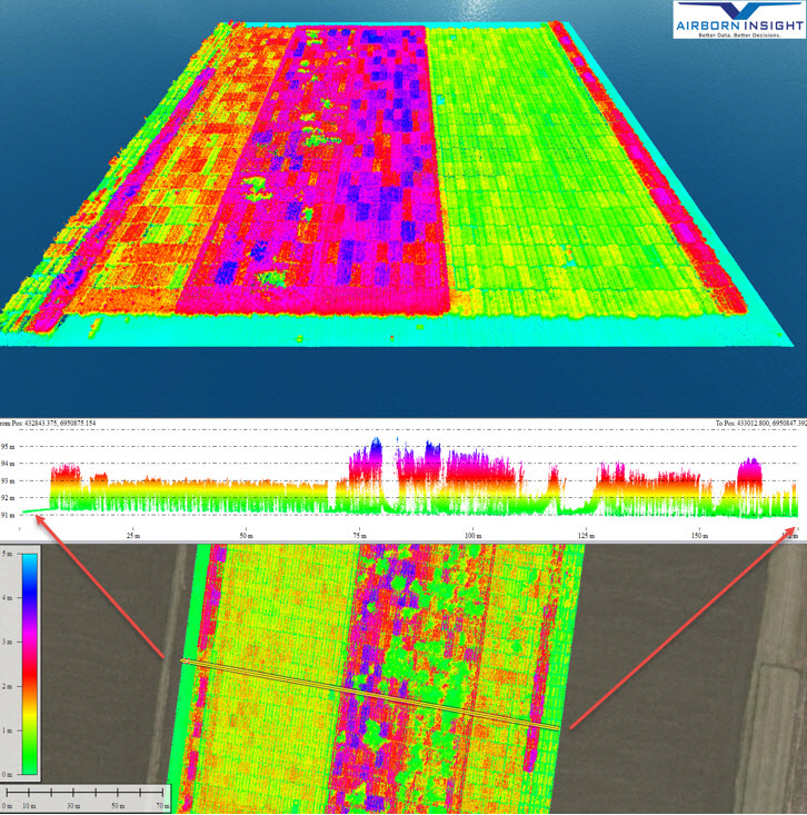
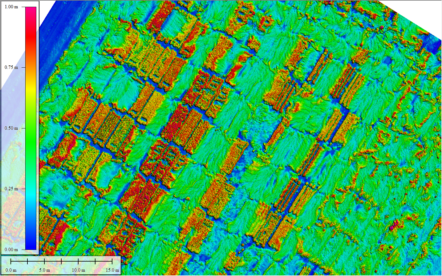
Our crop laser scans (LiDAR) provide accurate 3D point cloud data which enables precise and detailed mapping of plant structures, allowing researchers to analyse plant architecture, canopy cover, and spatial distribution. This data facilitates the extraction of plant parameters such as height, volume, and density, providing quantitative measurements for plant growth analysis and biomass estimation. It also aids in the identification of structural variations, such as lodging or disease-related deformities.
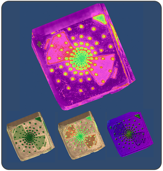
Data visualization enables researchers to comprehend complex datasets and identify patterns, trends, and relationships with ease. Our visual representation communicates findings, aiding in presenting results to stakeholders, collaborators, and decision-makers. It enhances data interpretation, allowing researchers to make informed decisions and derive actionable insights. Additionally, data visualization simplifies the identification of outliers, anomalies, or inconsistencies, helping to refine experimental designs and optimize agricultural practices for improved productivity and sustainability.


Various types, including high-resolution imagery for automated plant counting and sizing using machine learning, multispectral indices, thermal temperature data, and 3D measurements via laser scan.
Drone-based phenotyping can provide highly accurate measurements, often comparable to or even better than traditional ground-based methods. The accuracy depends on factors such as sensor quality, flight parameters, and data processing techniques.
Drone-based phenotyping has applications in crop breeding, precision agriculture, disease detection, yield prediction, environmental monitoring, and optimizing resource management, among others.
Yes, the use of drones for phenotyping is subject to local regulations. It is important to comply with airspace regulations, obtain necessary permits, and adhere to privacy and data protection laws.
Drone-based phenotyping accelerates the breeding process by providing rapid and detailed phenotypic data, facilitating the selection of desirable traits, identifying genetic markers, and supporting genotype-phenotype correlations.
Some limitations include flight time constraints, weather conditions, limited payload capacity, and the need for skilled operators and data processing expertise. Additionally, certain plant traits may require ground-based measurements for more accurate analysis.
When selecting a service provider, consider their experience, expertise, equipment quality, data processing capabilities, customization options, and customer reviews. Additionally, assess their ability to meet your specific research or crop management needs.
UAV-based phenotyping, remote sensing in agriculture, drone-assisted plant analysis, unmanned aerial phenotyping, high-throughput field phenotyping, imaging-based plant phenomics, unmanned aerial plant monitoring