Aerial Survey and Mapping

AERIAL DATA TO MAKE BETTER DECISIONS

Drone Survey and Aerial Mapping

AirBorn Insight combines technical expertise with high-performance equipment and robust methodologies to deliver high quality drone surveying and mapping services. Our professional engineering staff provide quality service and deliver results faster, empowering our clients to make critical decisions sooner. We offer maximum flexibility with our ability deploy the most effective drone sensors for each application, including LiDAR, photogrammetry, thermal, multispectral, and other specialist sensors.

Drone Survey and Aerial Mapping

WHAT IS Drone Survey and Aerial Mapping?

Survey DATA FROM ABOVE

Drone survey and aerial mapping refer to the use of unmanned aerial vehicles (UAVs), commonly known as drones, for collecting data and creating high-resolution maps and models of the Earth’s surface. This technology has gained significant popularity in recent years due to its efficiency, accuracy, and cost-effectiveness in various industries, including construction, agriculture, environmental monitoring, and urban planning.

Drone surveying involves the deployment of drones equipped with specialized cameras, sensors, and GPS systems to capture aerial images and collect data from specific locations or large areas. These drones can fly at different altitudes and capture images from various angles, providing a comprehensive view of the terrain. They can also carry out other tasks, such as LiDAR scanning, thermal imaging, and multispectral analysis, depending on the requirements of the survey.

Drone Survey and Aerial Mapping

Drone Survey and Aerial Mapping

BENEFITS OF OUR DRONE SURVEY AND AERIAL MAPPING SERVICES
Aerial Survey and Mapping
Accurate and reliable data

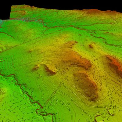
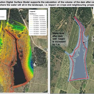
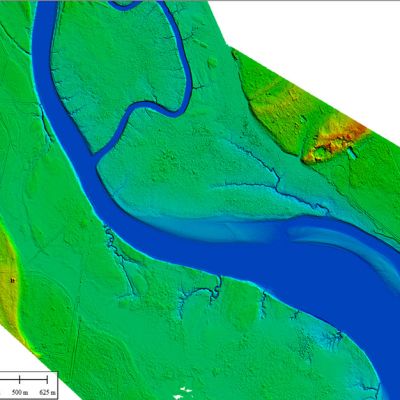
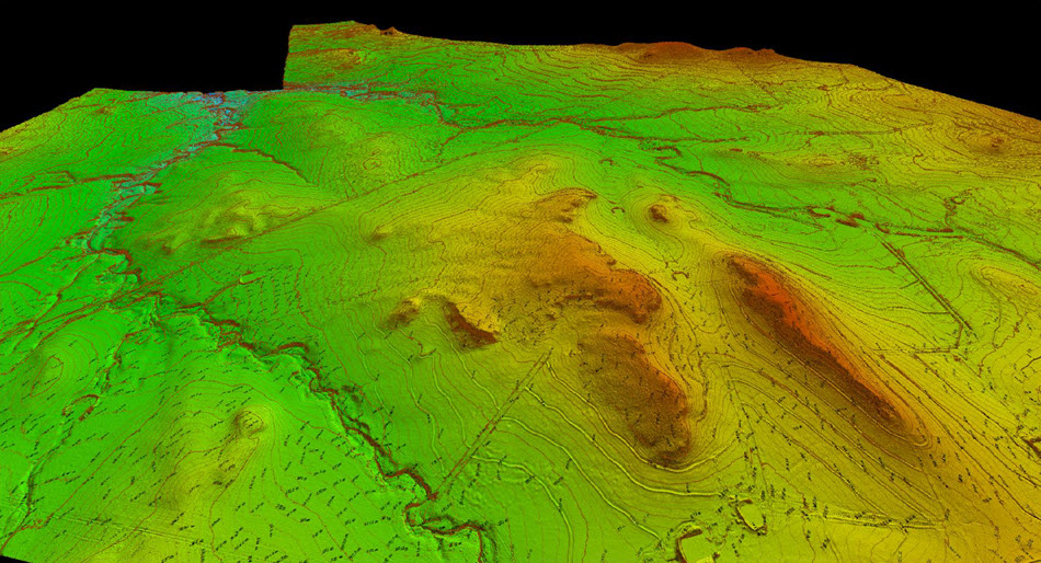
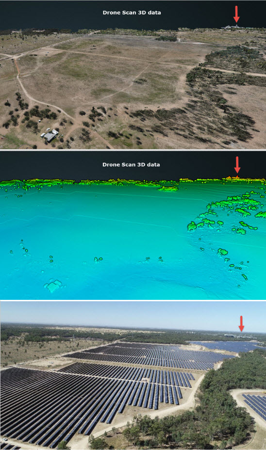
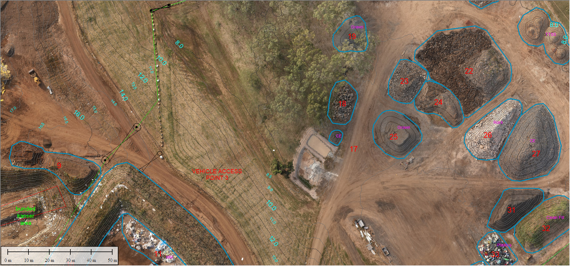
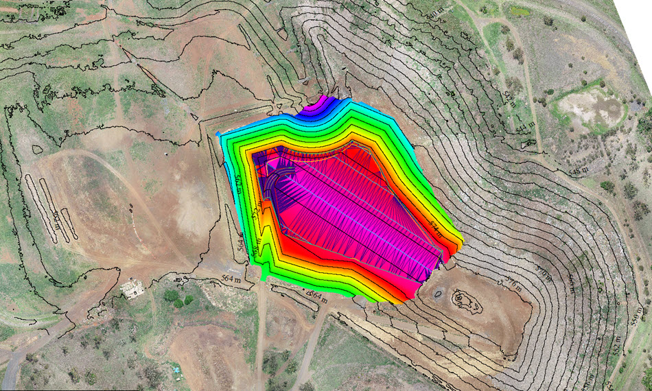
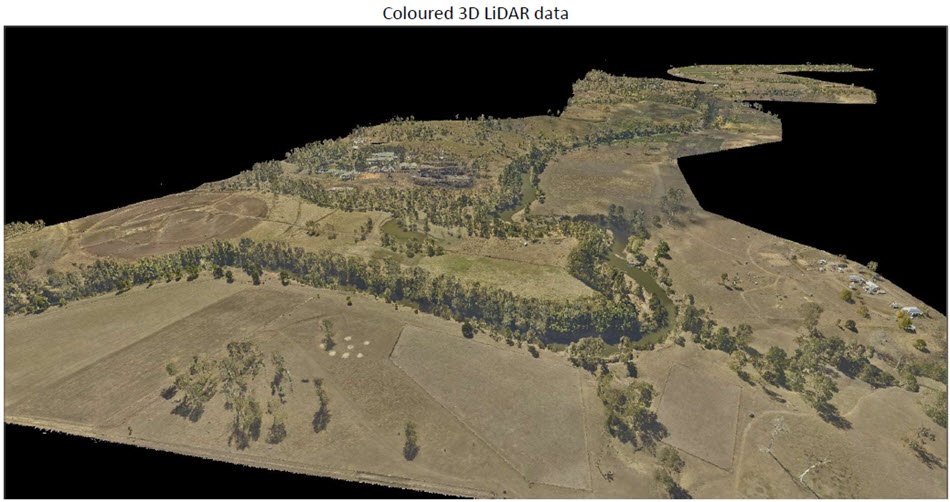
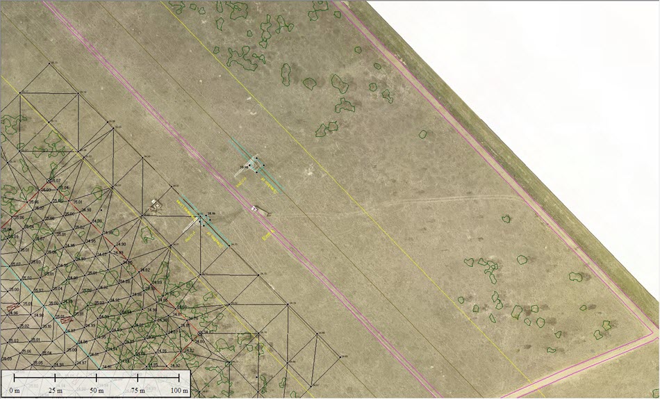
A single drone flight captures millions of data points, each containing valuable 3D geographic information.  This data can be represented in convenient formats including point clouds, digital terrain models (DTM), digital surface models (DSM), orthomosaics and site plans.

Aerial Survey and Mapping
Fast turn-around

Our aerial surveying drones allow for the efficient capture of vast amounts of survey imagery and data, even for complex and large-scale projects, within a short timeframe and without sacrificing accuracy.

Aerial Survey and Mapping
Safely Map Inaccessible Areas

The sky is no longer the limit.  Compared to traditional methods, aerial survey drones excel when it comes to accessing steep slopes, unstable areas or harsh terrain. We can safely monitor the performance of your site from a distance.

Aerial Survey and Mapping
Collaborate with 3D visualisation

View and measure survey models in high detail 3D and share. Gain deeper insights with an interactive digital twin of your project.

Aerial Survey and Mapping
Long-Term Monitoring and Trend Analysis

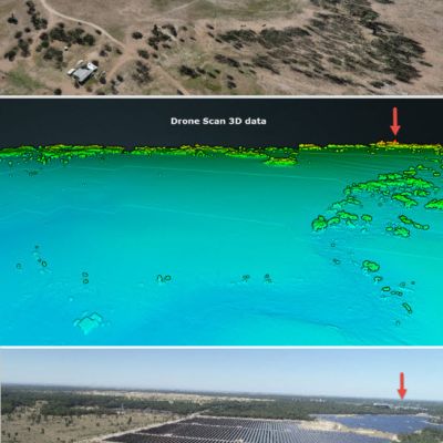
Our repeat surveys facilitate long-term monitoring and trend analysis. This allows for the detection of changes and patterns in environmental parameters, aiding in understanding and managing environmental issues.

Aerial Survey and Mapping
Cost-Effective

Our services provide cost savings by minimizing ground-based surveys and eliminating the need for manned flights over small and medium areas, making aerial surveys more accessible and affordable.


AirBorn Insight are our go-to provider for aerial survey and imagery. They fully understand our needs and are excellent at what they do. I am always impressed with the quality and accuracy of their work, especially for repeat survey. I frequently recommend AirBorn Insight to my clients and stakeholders.

Dr Micheal Cheetham Principal Scientist, Water Technology

Working with AirBorn Insight has been a valuable experience. Their accurate survey data helps us create compliance reports, make informed operational decisions, simplify design processes, and reduce survey costs. Their expertise, tailored services, and prompt responses have been greatly appreciated. We look forward to continuing our collaboration!

Fangzhou Du Ph.D. Woodlawn Eco-Precinct Engineering Manager, Veolia


AirBorn Insight have provided aerial surveying services for us on numerous occasions, and we have always been satisfied with the results.

Norm Purcival Principal Program Development, Toowoomba Regional Council
Project Gallery

Drone Survey and Aerial Mapping

APPLICATIONS OF DRONE
SURVEY AND MAPPING

We pride ourselves on our state-of-the-art equipment and advanced technology. Our fleet of drones and aircraft is equipped with the latest sensors and imaging systems, enabling us to capture incredibly detailed and precise aerial data. Whether you need orthophotos, topographic maps, 3D models, or thermal imaging, we have the tools and expertise to deliver exceptional results.

1. Volumetric Surveys for Mines, Quarries, and Landfills

Drone surveys revolutionize volumetric surveys by providing accurate and efficient measurements of stockpile and excavation volumes. They enable precise inventory management, optimizing resource allocation and reducing costs. The real-time data obtained from drone surveys helps monitor excavation progress, assess material extraction rates, and plan reclamation efforts effectively. This information aids in compliance with regulations, streamlines operations, and enhances overall productivity.

2. Erosion Monitoring

Drone surveys play a crucial role in erosion monitoring, providing high-resolution data for assessing erosion patterns and identifying vulnerable areas. With frequent surveys, drones enable early detection of erosion hotspots, facilitating timely erosion control measures. The detailed data collected allows for accurate erosion analysis, helping land managers implement targeted erosion prevention strategies and mitigate environmental impacts. With drone-based erosion monitoring, landowners can proactively protect their sites, ensuring long-term stability and sustainability.

3. Data Inputs to Flood Modelling

Drone surveys provide invaluable data inputs for flood modelling, enhancing flood risk assessment and management. Drones enable accurate mapping of flood-prone areas and the creation of detailed digital elevation models (DEMs). These datasets serve as critical inputs for flood modelling software, improving the accuracy of flood predictions and facilitating informed decision-making. Drone-based data collection significantly reduces the time and cost associated with traditional survey methods, enabling more frequent updates and better preparedness for potential flood events.

4. Stockpile Measurements

Drone surveys offer significant advantages in stockpile measurements, revolutionizing inventory management for mines, quarries, and landfills. With their ability to capture detailed topographical data, drones provide accurate volume calculations and 3D modeling of stockpiles. These measurements enable precise inventory control, minimizing overstocking or stock shortages. Drone surveys also enhance safety by eliminating the need for personnel to manually climb or measure stockpiles. Real-time stockpile data facilitates efficient logistics planning and optimizes material usage, ultimately leading to cost savings and improved operational efficiency.

5. Environmental Monitoring

Drone surveys contribute to effective environmental monitoring by capturing high-resolution imagery and data for assessing various environmental parameters. They enable the monitoring of vegetation health, identifying areas of stress or invasive species encroachment. Drones can also provide valuable insights into water quality by capturing images and samples from water bodies for analysis. Additionally, drones aid in habitat assessment, helping monitor wildlife populations and supporting conservation efforts. By providing accurate and up-to-date environmental information, drone surveys assist in complying with environmental regulations, promoting sustainable practices, and protecting natural resources.

6. Drainage Analysis

Drone surveys facilitate comprehensive drainage analysis by capturing detailed topographic information and hydrological patterns. By generating high-resolution digital terrain models (DTMs) and elevation maps, drones help identify areas prone to poor drainage or flooding risks. This data aids in designing effective drainage systems, optimizing water management strategies, and mitigating potential water-related issues. Drone-based drainage analysis enables more precise and cost-effective planning, reducing the risk of infrastructure damage and ensuring efficient water flow across the surveyed area.

7. Coastal Monitoring

Drone surveys contribute to effective environmental monitoring by capturing high-resolution imagery and data for assessing various environmental parameters. They enable the monitoring of vegetation health, identifying areas of stress or invasive species encroachment. Drones can also provide valuable insights into water quality by capturing images and samples from water bodies for analysis. Additionally, drones aid in habitat assessment, helping monitor wildlife populations and supporting conservation efforts. By providing accurate and up-to-date environmental information, drone surveys assist in complying with environmental regulations, promoting sustainable practices, and protecting natural resources.

8. Topographical Surveys and Site Plans

Drone surveys provide significant benefits for topographical surveys and site plans by capturing a comprehensive and accurate representation of the surveyed area’s topography. This data enables precise mapping of contours, elevation changes, and surface features, essential for designing infrastructure, planning construction projects, and site development. Drone surveys significantly reduce the time and cost traditionally associated with ground-based survey methods, allowing for more frequent and efficient data collection. The detailed and up-to-date information obtained from drone surveys enhances decision-making, minimizes errors, and improves overall project efficiency and success.

Drone Survey and Aerial Mapping

WHY USE AIRBORN INSIGHT FOR AERIAL SURVEY AND MAPPING?

Drone survey and mapping have emerged as valuable tools in various fields, revolutionizing traditional methods of data collection and analysis. These unmanned aerial vehicles (UAVs) equipped with advanced imaging and sensing technologies offer a wide range of applications with their ability to capture high-resolution images and collect data from challenging or inaccessible areas.

Reputation and References

We have a strong reputation in the industry, supported by positive client testimonials and references. Our reliability, quality of service, and track record for aerial LiDAR mapping have earned us the trust and recommendation of our clients.

Aerial Survey and Mapping

Comprehensive Project Management

We provide all the essential elements for successful LiDAR services – professional consultation, precise surveys, in-house data processing, and proficient reporting and drafting services.

Professional Staff

Our professional engineers and licensed surveyors ensure precise data collection and accurate analysis for informed decision-making.

Aerial Survey and Mapping

Reporting, Drafting and Visualization

We make it easy to interpret results. Our easily understandable formats facilitate the implementation of appropriate actions based on clear findings.

Efficient and Reliable Services

We can achieve the right outcome, first time, under a proven safety management system. We offer immediate deployment while taking care of costly equipment and the complexities of aerial LiDAR operations – training, maintenance, aviation safety management, documentation, and liability.

Aerial Survey and Mapping

Advanced Technology

We utilize cutting-edge systems equipped with high-quality LiDAR sensors, cameras, and data collection instruments. Our advanced technology enhances data accuracy and enables us to capture detailed mapping data for comprehensive analysis.

Data Analysis Capabilities

Our in-house data analysis capabilities, including advanced software tools and techniques, allow us to process and interpret data effectively. We provide valuable insights for informed management decisions and actionable recommendations.

Aerial Survey and Mapping

Customization and Flexibility

We are technically proficient at providing flexible solutions. Our engineers can adapt drone flights, LiDAR sensor configurations, and data analysis approaches to ensure the unique needs of your project are met.

Drone Survey and Aerial Mapping

Drone Survey and Aerial Mapping FAQ

Drone surveying is the process of using unmanned aerial vehicles (UAVs) equipped with sensors to collect aerial data for mapping, 3D modelling, land surveying, and other applications.

Drones equipped with cameras or LiDAR sensors capture images or point cloud data from above. This data is then processed using specialized software to create accurate maps, models, and measurements.

Drones offer several advantages such as faster data collection, cost-effectiveness, improved safety, access to hard-to-reach areas, high-resolution imaging, and the ability to generate detailed 3D models.

Various industries including construction, agriculture, mining, infrastructure, environmental monitoring, and real estate can benefit from drone survey services.

Drone surveys can collect data such as aerial imagery, orthomosaic maps, digital surface models (DSMs), digital terrain models (DTMs), point clouds, thermal imagery, and elevation contours.

Yes, drone operations are subject to regulations and guidelines set by the Civil Aviation Safety Authority. These regulations often include requirements for pilot certifications, flight restrictions, and safety protocols.

A reputable drone survey service provider should have CASA licensed and certified drone pilots, expertise in aerial data collection, processing, analytics, and knowledge of local aviation regulations.

The turnaround time can vary depending on the scope of the project and data processing requirements. It can range from a few days to a couple of weeks.

Drone surveying is often more cost-effective and time-efficient compared to traditional surveying methods, as it eliminates the need for ground-based measurements and allows for faster data collection.